Irvine's New Wildfire Sensor Network: What Homeowners Should Know
The City of Irvine and SensoRy AI are deploying a large-scale network of ultra-early wildfire-detection sensors across the Irvine Open Space Preserve, with the full rollout planned for early 2027 and funded through a California Department of Conservation program. The goal is to catch an ignition in its first minutes, before a camera or a resident spots it, and get that information to firefighters immediately.
For anyone who lives along Irvine's open space edges, Turtle Rock, Shady Canyon, Quail Hill, Portola Springs, Orchard Hills, this is one of the more consequential city announcements of the year, and it barely made a ripple.
What is the sensor network and how does it work?
Per the City of Irvine's July 27, 2026 announcement, the city is partnering with SensoRy AI, working alongside the Irvine Ranch Conservancy (IRC), the city's long-time nonprofit land management partner, and with support from the Orange County Fire Authority.
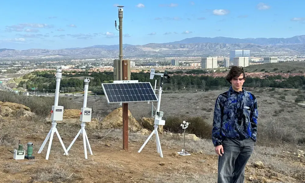
The technology is a wireless mesh sensor network. Rather than watching for smoke visually, the sensors continuously measure environmental conditions on the ground and use proprietary analysis to detect a fire at the earliest possible moment. They push instant notifications and real-time updates to firefighters, including information that helps predict how fast a fire will grow and which direction it will move.
Three design choices matter here. The sensors are low-cost, easily deployable, and require no existing infrastructure, meaning they can go into remote, high-risk terrain where you can't run power or mount a camera tower. That's precisely the terrain that surrounds Irvine.
The city ran a test deployment last year with SensoRy AI and OCFA. Per the city, the test sensors performed better than anticipated. In one recent deployment, the network detected and reported an ignition from more than a mile away before either residents or camera systems identified it.
Funding for the large-scale rollout comes through the California Department of Conservation's Regional Forest and Fire Capacity (RFFC) Program, with deployment across the Irvine Open Space Preserve planned for early 2027.
Who is SensoRy AI?
This is the part of the story I keep telling people about. SensoRy AI was founded by Ryan Honary, who started the company while still in high school, the technology began as a science project driven by his own concern about wildfire devastation. He's heading to Stanford University in the fall on a Wildfire Fellowship and will stay directly involved in the work.
Honary has said the second-generation hardware is smaller and more efficient than the first, and that the AI models have gotten more accurate as they've trained on the data collected since last year's deployment.
Michael O'Connell, President and CEO of the Irvine Ranch Conservancy, said IRC backed him from the beginning because they saw the potential in both the technology and the young man behind it. Mayor Larry Agran framed the city's rationale plainly: protecting the open space also protects the neighborhoods bordering it.
Why should Irvine homeowners care?
Because wildfire risk is now a housing cost, not just a safety concern. California homeowners have watched insurance availability and premiums move sharply in fire-adjacent areas over the past several years. The Palisades and Eaton fires in 2025 killed 31 people and destroyed more than 16,000 structures, with economic losses well over $100 billion. Insurers are pricing that reality into every wildland-urban interface in the state.
I am not going to claim a sensor network lowers anyone's premium. It doesn't work that directly, and nobody should buy a house on that assumption. What I will say is that demonstrated municipal investment in early detection and risk assessment is exactly the kind of thing that goes into how a region gets evaluated over time, and it's a fair, concrete answer when a buyer relocating from out of state asks, "what is Irvine actually doing about fire?"
Because it complements, rather than duplicates, what already exists. The network is explicitly designed to go beyond the Alert CA wildfire camera system by filling viewshed gaps, the blind spots cameras can't see, using a fundamentally different detection method. Redundancy in fire detection is not waste.
Because the geography is regional. The city, SensoRy AI, and IRC hope this becomes a network spanning the coastal open spaces of central Orange County, including areas around Laguna Beach, Newport Beach, and Crystal Cove State Park. Fire doesn't respect city lines, and neither should detection.
And because it's part of a broader pattern. Irvine has also been reducing fuel loads through habitat restoration work in Bommer Canyon. Detection plus prevention is a more serious posture than either alone.
What should homeowners near open space do anyway?
Technology on the hillside doesn't replace what happens at your property line. If you live along Irvine's open space edge, the basics still carry the most weight: maintain defensible space, keep gutters and roof valleys clear of dry debris, know your evacuation route before a Santa Ana event, and sign up for the city and county emergency alert systems. Talk to your insurance agent annually rather than at renewal-shock time.
For buyers: ask about fire-hazard severity zone designation and insurance availability before you're in escrow, not after. In some Orange County pockets, insurance has become the gating item on a transaction rather than a formality.
Frequently asked questions
When will the sensors actually be installed? The city plans the large-scale deployment across the Irvine Open Space Preserve in early 2027, following the successful test deployment conducted last year with SensoRy AI and the Orange County Fire Authority.
Do these sensors replace the wildfire cameras? No. The city describes the network as designed to complement and go beyond the existing Alert CA camera system, filling gaps that cameras can't see and using different detection technology.
Who is paying for it? Funding comes through the California Department of Conservation's Regional Forest and Fire Capacity Program, with the City of Irvine and the Irvine Ranch Conservancy carrying out the deployment.
Will this lower my homeowners insurance? There's no basis to promise that, and I wouldn't. Insurance pricing depends on carrier models, statewide regulatory conditions, and property-specific factors. Treat improved detection as good news for safety, not as a premium strategy.
If you're buying near Irvine's open space and want a frank walkthrough of what the fire-risk and insurance picture looks like for a specific property, that's a conversation I'd rather have with you early than late.
Details from the City of Irvine's July 27, 2026 announcement. This is general information, not insurance, legal, or financial advice.
Final Thoughts
Choosing the right advisor makes all the difference. Connect with Ruth Bruno Real Estate to get started.
Subscribe & Stay Connected!
I'm Ruth Bruno, your Irvine neighbor, crossing guard, and local REALTOR®. Serving Irvine and Orange County.

Subscribe to my YouTube channel here!
Visit my website here!
Thinking of buying?
How about selling?
Always happy to help.


